landscape_management

Biodiversity and Landscape Management

Our team, with the advice of specialists in the fields of flora and fauna, carries out field surveys to identify conditions of affected habitats and presence of protected species. This allows us to an early identification of critical environmental components (protected flora, fauna and Natural Sites). This information is translated and integrated in a geographic information system (GIS) and crossed with the proposed project layouts.

Taking as baseline exiting cartographic information of Habitats of Natural Interests (1:50.000 -2002) we put our efforts on validation of the same and interpretation of existing land uses through field surveys. This led to the development of more accurate cartography (1:5.000), ultimately providing a proper impact assessment of the existing habitats.

Innovative use of technologies resulted in a successful GIS based integration of thematic layers that enhanced project risks understanding and impacts on environment and facilitated decision making processes.

Stakeholders Management, correct address of their claims and demands to get a broadly supported definition of compensatory and mitigation measures.

Some examples of our work

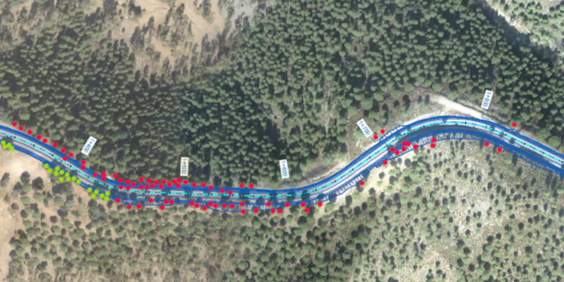
Arboriculture Survey

  • Affected specimens identification
  • Translocation viability assessment
  • Individual protections for specimens within work area definition.

Survey Drawing (affected specimens of P. pinea (red spots) and Q. ilex (green spots)
Biodiversity Assessment

  • Defragmentation Assessment  and Permeability Enhancement
  • Collision Risk Reduction
  • Works temporal limitations (during earthworks)

Wildlife crossing to enhance permeability in the existing road

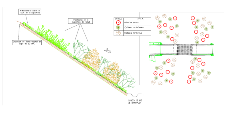
Landscape Integration

  • Aesthetic quality of new generated areas enhancements (fills and embankments) through hydroseeding, native shrubs and trees planting, etc.
  • Fauna crossings effectiveness improvement through native planting.

Embankments environmental integration (left) and fauna crossing enhancement (right)
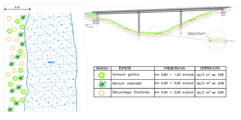
Ecologic Restoration

  • Works affected riverine areas restoration through native tree planting.
  • Habitats of interest areas recuperation: native shrubs and trees planting.

Riverine areas restoration
environmental_impact_assessment

Environmental Impact Assessment - Monitoring

Our scope of works includes the whole Environmental Evaluation process, namely:

  • Identification of environmental factors and their analysis and project’s impact on them.
  • Public consultation and administrative management for the production of an Environmental Statement for the EIA report.
  • Establishment of a Mitigation Measures Project for the detailed design and an Environmental Monitoring for the construction phase.

We conduct the Environmental Impact Assessment (EIA) Procedure of Projects, Plans and Programs pursuant European Directives (2001/42/EC and 85/337/EEC) and national and regional regulations.

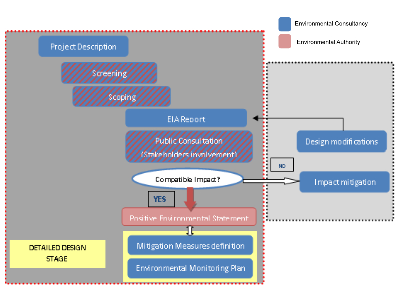
Environmental Evaluation for a civil infrastructure project, involves the following stages: 

  1. Screening (authorities and relevant associations information & consultation period)
  2. Scoping (establish terms of reference for EIA)
  3. Environmental Impact Assessment Report development (methodology design, baseline data collection, impact analysis, preliminary mitigation measures identification and environmental monitoring plan)
  4. EIA Report submission to competent authorities so that they conduct a public consultation (stakeholder’s involvement).
  5. Mitigation measures detailed definition (drawings, bill of quantities and tender documents), and Environmental Monitoring Plan design. Being all process compliant with Environmental Statement.

We provide our extensive environmental assessment regulations and procedures experience and knowledge in all relevant areas, namely: wildlife, protected areas, statutory regulations, biodiversity, landscape management, integration and monitoring. 

EIA process approach followed for this project is outlined below with reference to the roles of both the consultant and the authority and the relationship and joint procedures to be carried out by each party.

Our team not only has an in-depth understanding and expertise in all relevant environmental factors like hydrological and geological variables, flora, wildlife and protected areas, but also in the technical side provided by project designers and a key input to understand the project implications.

We have a comprehensive capacity for applying methodologies and evaluate both quantitative and qualitative impacts by using geographical information systems (GIS), scientific references, models, and/or expert’s opinions as necessary.

Ready to Work Together?

Get Started